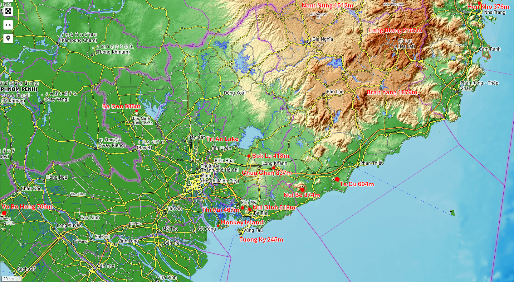
It is a popular sport in western countries. Vietnam is slowly catching up. More people start looking for an escape of the city on weekends. Here a map from southern Vietnam:
 Some popular destinations I tested myself, ordered by distance from the center of Saigon:
Monkey Island
 This is a short drive from Saigon, including a ride with a ferry from Nha Be. The destinations are a little over an hour away on your bike. First and second stop:
- Location: Khu dự trữ sinh quyển thế giới, 2nd: Khu căn cứ Vàm Sát Đảo Khỉ
- Distance: 40.1 km, 1h05 - second 52.8 km, 1h19
- More Information: Monkey Island, the ferry fee is 7k VND
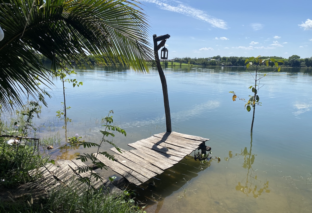
I traveled to a few times. First trip into the mangrove forest was on January 15th, 2019 with a class trip from AISVN and a closer destination. The second trip was another 20 minutes down the road. There you have a 40 minute walk through a Mangrove forest. Then you can drive back with a motorboat in 5 minutes, or walk back.
- Monkey Island I - 2019-01-15 with 85 students from grade 9 of AISVN
- Monkey Island II - 2026-03-02 with Eddie, Simon and Pablo
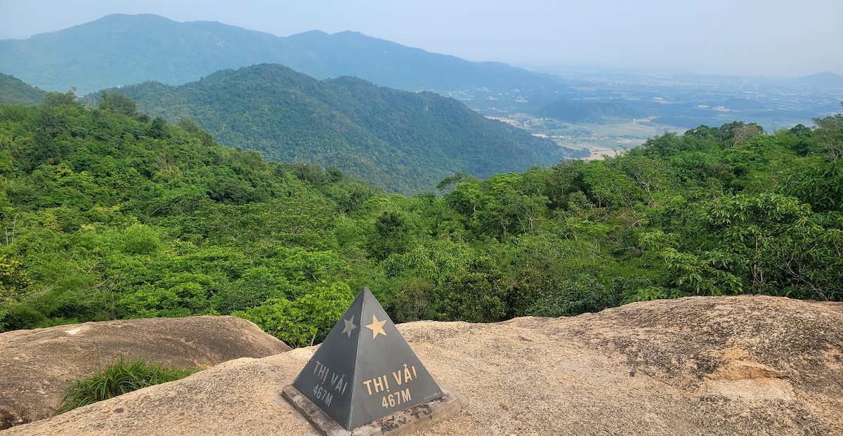
Núi Thị Vải - 467m
- Location: Núi Thị Vải and distance: 57.5 km , 1h14
- Details: height 467 meters, round trip about 1h40 for 5.07 km. Needs 913 kcal.
I’ve been there three times, the second time (see Strava with 3D flyover) I finally found the “peak” which is 50 meter below the peak and 200 meters away from it on a rock plateau with a view.
- Núi Thị Vải I - 2025-06-20 - got to the top but could not find the cairn
- Núi Thị Vải II - 2025-07-24 - top, loop 1h40, picture of cairn 50 m below peak
- Núi Thị Vải III - 2026-05-03 - looping again, this time 1h50
Núi Dinh - 491m
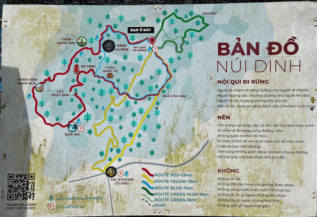
- Location: Núi Dinh and distance: 81km, 2h07
- Details: height 491 meters
- Blue route: 8.12km, 5h25. Needs 1116 kcal.
- Red route: 14.97km, 4h57. Needs 2048 kcal.
Been there three times, the second time finishing the red loop in 4:57 on 2025-07-07 and burned 2048 kcal total. The total distance was 14.97 km, elevation gain 706 meter. Maximum height: 482m on Strava 2026-02-24 and 492m on Apple watch 2025-07-07.
- Núi Đinh I - 2023-11-26 - more than 6 hours with shortcut at the end of the red loop
- Núi Đinh II - 2025-07-07 - finished the red loop after 4h57 (3h49, 14.97km)
- Núi Đinh III - 2026-02-24 - blue route with Pablo, Simon and Eddie after 5h25 (3h30, 8.12km)
Tri An: Hồ Trị An - Tri An Lake
 Less than 2 hours from HCM a quiet place to spend the night in a tent, enjoy BBQ at the lake and take a swim or boat ride. Been there twice, but never stayed.
Vũng Tàu - Tương Kỳ - 245m
- Location: Thiền viện Chơn Không, and distance: 99km, 2h31
- Details: 210m or 245 meters high
The mountain Tương Kỳ in Vũng Tàu is only 210 meters high. At least it’s a short hike though some green. Location: 44 Vi Ba, Phường 1, Vũng Tàu, Bà Rịa - Vũng Tàu.
You can also take the ferry from Can Gio. It is 70k for the motorbike and 50k for a passanger. On your own therefore 120k, if you’re riding with someone it’s 170k.
Núi lửa Sok Lu - 418m
You can see this mountain from the Tri An Lake, but it’s actually not a hiking spot. The nearby town is already at 180 meter elevation, and you can drive through banana fields to get closer and a height of 280 meters. The peak is a little more than 400 meter. A farmer told me that you have a narrow road up that is best 7:00 am to 8:00 am to avoid oncoming traffic since you can’t pass. I could not find this trail on satellite pictures or the Strava heat map. Probably best to find another goal. Núi Chứa Chan is not far away! I checked it out on 2026/03/11.
Núi Chứa Chan - 837m
- Location: Núi Chứa Chan, distance: 100km, 2h22
- Details: height 837m, but a surrounding elevation already 200m
- Entrance: free from the back side (20k parking bike a day)
- Cable Car in 2026 from 6:00 - 17:00: 150k up, 100k down, combo 200k
With 837 meters the second highest isolated mountain in the Mekong region, behind the Black Virgin Mountain - Núi Bà Đen. I visited it 2 times:
- Checking out the 5km round course and 100k cable car 150k 2026-03-11
- Making it to all 3 tops, because it is a construction site - 2026-04-30
Black Virgin Mountain - Núi Bà Đen - 986m
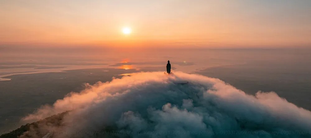 About 3 hours from Saigon is this highest point in the Mekong delta with almost 1000 meters height. Further information:
- Location: Núi Bà Đen, distance: 106 km, 2h33
- Details: for the 900 meter height difference plan 4 hours, 1625 kcal
- Entrance 2025: 10k, cable car Đỉnh Vân Sơn 400k, Chùa Hang 250k
- Entrance 2026: 10k, main cable car 450k, no one-way ticket
Now I’ve been there already 4 times! Here are a few things to consider: If you are not trained it will take at least 4 hours to get up to the top. We tested this on February 16th, 2026 and had to stop the ascent halfway. There are at least 3 ways up and down, from the cable car you can take 2 different ones:
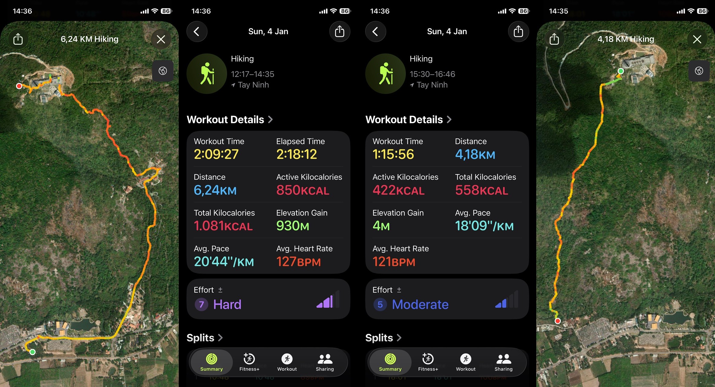
Another thing is to consider the time of the day and distance from the city. From 2026 on you have to start your ascend before 11 am. In 2025 even 2:00 PM was possible. A park warden let’s you enter your name and phone number and size of group into a book before you can climb up.
- Black Virgin Mountain I - 2021/12/24 - Covid-19
- Black Virgin Mountain II - 2025/12/12 - 350 meters
- Black Virgin Mountain III - 2026/01/04 - to the top
- Black Virgin Mountain IV - 2026/02/16 - up to 500 meters height
Vườn quốc gia Cát Tiên - Cat Tien National Park
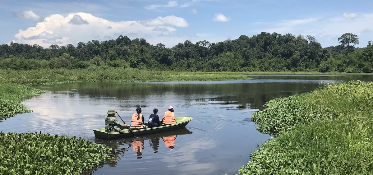 About three hours from the city. Been there twice. Above a picture from crocodile lake deep in the jungle and a few brave students!
- Location: Ấp 1, Tân Phú District, Dong Nai 76813, 4.7 stars on Google (1201 reviews)
- Distance: 148 km, 2h55
- Details: Bus to drop-off for crocodile lake is 8.62km from ferry, takes 17 minutes, then walk through the forest 4.55km, 1h15, 473 kcal
In total I’ve eeen there three times, but only two times inside of the National park:
- 2019/01/03 On the trip to the north, Madagui and Danang. And the leeches got me!
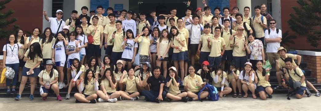
- 2019/05/16 Cat Tien National Park II with IB Biology and a few other students from AISVN
Núi Tà Cú - 694m
- Location: Núi Tà Cú, distance: 163 km from Saigon, 3h21 by bike
- Details: height 694 meters, round trip about 5h10 for xxxx km. Needs xxxx kcal.
First I only got to the entrance with Núi Tà Cú I on 2026/03/15. Minh conquered the top with Mỹ Tâm on March 14th.
- Núi Tà Cú I - 2026-03-15
- Núi Tà Cú II - 2026-05-01
Vồ Bồ Hong - Núi Cấm - Forbidden mountain - 705m
- Location: Vồ Bồ Hong, distance: 255km, 5h21
- Details: 705 meters high, has a cable car to 550m, surrounding 40m
- Hike: 3.09 km, 2h43, 628 kcal (battery died on iPhone)
Nhoc Minh organized this trip for Tet 2024 up the whole 640 meters up. Location: Đỉnh Núi Cấm Cách Vồ Bồ Hông 100m về hướng phía sau lưng Đài Truyền Hình, An Hảo, Tịnh Biên, An Giang 880000, Vietnam at google top: Điện Bồ Hong
- 2024-02-17 organized by Minh during Tet, with Hieu, Tram Tram, Thanh Ha, Thuyan, Hong Ngoc, Thanh, Nga,
- 2025-01-31 Again in An Giang
Núi Nam JerBri in the Nam Nung Nature Reserve - 1578m
- Location: Nam Nung and distance: 270 km , 6h32
- Details: height 1578 meters, round trip on website: 2d1n.
The website wetrek.vn has a Vietnamese description of the hike there from 2020. The núi Nâm Nung is 1.512m high, and deeper into the forest núi JerRri is 1578m high.
Núi Lang Biang - 2167m
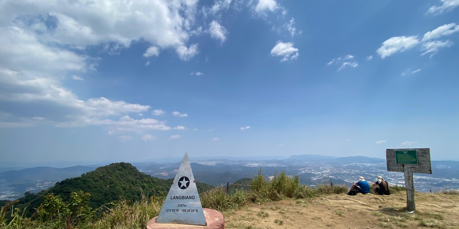
- Location: Lang Biang near Da Lat, and distance: 314 km, 6h43
- Details: height 2167 meters, surrounding base is 1500 meter
- Entrance: 50k, someone reported 5 hours for the 8 miles/13km round course
Went there on a Daytrip to Núi Lang Biang in April 2026. Total distance: 12.8 kilometer in 3h53 with breaks.
Núi Chư Yang Sin - 2420m
- Location: Chư Yang Sin, distance to Thác Krông Kmar 356 km 7h47
- Details: height 2442m and 2405m according to Google Review, surrounding area is at 500m elevation, located between Dalat and BMT
- Entrance: Tour operators from BMT for 3.4m per person, another review stated 8 hours, and one that it is closed for foreigners. More on the Wikipedia article in Vietnamese.
The description from one travel website reads:
Day 1: Trekking Journey - 5 km
Your adventure begins with a pick-up from your hotel in Buon Ma Thuot or the Dak Lak area at 6:00 AM. After gathering at the homestay for personal hygiene and breakfast at 7:00 AM, we’ll transfer to the foot of the mountain by 7:30 AM.
At 8:00 AM, we’ll embark on our trek. As we navigate through lush forests and cross streams, you’ll experience the thrill of tackling steep inclines while immersing yourself in the diverse ecosystem, rich with rare and protected flora and fauna.
Around 11:00 AM, we’ll take a break for lunch on large boulders, where you can relax and listen to the soothing sounds of nature, washing away any fatigue from the day.
By 4:00 PM, we’ll reach the base of the summit, greeted by cool streams, majestic waterfalls, and vibrant rhododendron flowers in full bloom near the peak. Here, we’ll set up camp, freshen up, and enjoy delicious local dishes. Engage in fun activities that provide a fantastic opportunity to bond with fellow trekkers—these experiences are sure to be unforgettable.
At 9:00 PM, we’ll wind down and rest for the night.
Day 2: Summit Trek and Descent - 9 km
We’ll rise early at 6:00 AM to begin a new day. While enjoying breakfast at 6:15 AM, take a moment to breathe in the fresh mountain air and watch the first rays of sunlight pierce through the forest canopy.
At 7:00 AM, we’ll continue our ascent for 2 km to the summit. You’ll navigate through uniquely shaped boulders and may even reach out to touch the clouds. Enjoy the fruits of your labor with a cup of fragrant tea while soaking in the stunning views of the lush green forests and the grandeur of waterfalls cascading from the highlands—a breathtaking sight.
By 10:00 AM, we’ll make our way back down to the campsite.
At 11:00 AM, we’ll enjoy lunch and pack our belongings in preparation for the descent.
By 5:00 PM, we’ll have dinner at a traditional longhouse, featuring local specialties. Experience a unique cultural exchange with the indigenous community, highlighted by a captivating gong performance.
Finally, we’ll return to your hotel in Buon Ma Thuot City or the Dak Lak area at 6:30 PM, concluding an incredible journey filled with adventure and cultural richness.
Hòn Ngang - Angel mountains in Nha Trang - 352m
- Location: Hòn Ngang or Cô Tiên, distance: 441 km, 8h33
- Details: 352 meters high, no entry fee, second peak is highest and 1.53 km away, 45 min
- Hike: 4.10 km to all 3 peaks and return, 1h43
- One way: 1.61 km, 351 m height, 36min 30s (Strava, Apple watch water damage)
On my trip to Nha Trang I decided one afternoon to try this hike, recommended by Minh. Started late at 17:08 and hiked the 4.10 km forth and back in 1:34 with an elevation gain of 462 meters.. Highest point 348m in Strava after 1.53 kilometers. Second account with iPhone measured 347 meters. The third peak seems to be a little lower. Ascent to the second one is very steep. The descent was in the dark! But I got a phantastic AQI of 2!
- 2025-08-29 Angel Mountain in Nha Trang 17:18 - 18:27 into the darkness
Núi Chư Mư - Chư H’Mu- 2021m
- Location: Chư Mư - Chư H’Mu, distance: 442 km, 9h44
- Details: 2021 meters and one of the rather challenging paths in Vietnam, usually 2d1n or 3d2n
- Hike: 26km and 22 hours (22.07km up and return, 20h03 on Google) on one day
Chu Mu is located in Ea M’Doal commune, M’Drắk district, Đắk Lắk province – one of the border areas between the Central Highlands and the South Central Coast, close to the core area of the Chu Yang Sin special-use forest and the Ea Sô Nature Reserve.
Description on wetrek: https://wetrek.vn/bai-viet-thanh-vien/kinh-nghiem-trekking-chu-mu.htm And then there is Виктор Викторович who did it in one day. It looks like he started at this lang làng trên location. It looks (like all the other photos) he only got close to about 1910m. The starting point is at 490m height, no path on Strava, but on OpenStreetMaps. One way looks like 10k as-the-crow-flies.
Mỏm Đá Tử Thần, Meo Vac, Ha Giang Loop - 1320m
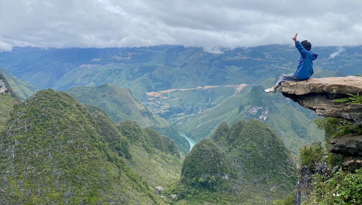
- Location: Mỏm Đá Tử Thần, distance: 1929 km, 1d14hr
- Details: The rock overhanging the valley makes for great pictures. Also called “Ha Giang Loop Skywalk”
- Hike: It’s only 800 meters from the parking lot at 1260m height, and elevation gain of about 67 meters to this 1320m high “peak”. But the last part to the very top is steep and fun! And if someone tells you about “professional” footwear, look at the woman actually climbing the steep mountainsides next to your easy road. They just have flip-flops!
Went there with Minh on 2025-11-04, see Meo Vac for details. And the Ha Giang loop a second time in 2025.
Sa Pa - Phan Xi Păng - Fansipan - 3147m
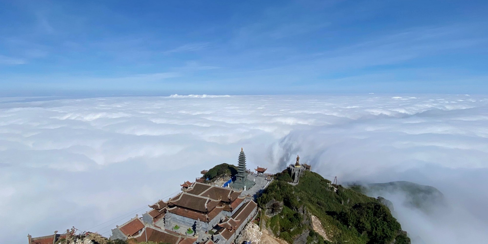
- Location: Phan Xi Păng, distance: 1816 km, 1h 11hr
- Details: Starting point is at the Núi Xẻ Ranger Station Trạm Tôn, and you definitely need a guide to hike up the mountain. See the Google review for disappointed hikers. Currently about 1.5 million. Start at 1950m height.
It is the highest peak in southeast Asia, including Vietnam, Laos and Cambodia. I’ve been 3 times in Sapa, and 2 of these times with my own bike, and these both times up to Fansipan. 2019 after workshop with bus from Hanoi, then 2023 and cable car to the top, 2025 hiked by foot!
- Sapa I - 2019
- Sapa II - 2023-07-13 by bike and up with the cable car
- Sapa III - 2025-10-29 with Shutte and Liz Venter from South Africa by foot. For this, check out One week in Hanoi and Sapa 2025 and the Strava link with 3D flyover
Summary table
| place | distance | time | height | hiking distance | hiking time | date |
|---|---|---|---|---|---|---|
| Khu dự trữ sinh quyển thế giới | 40 | 01:05 | 10 | 1.3 | 00:30 | 2019/01/15 |
| Khu căn cứ Vàm Sát Đảo Khỉ | 53 | 01:19 | 15 | 2.5 | 00:40 | 2026/03/02 |
| Núi Thị Vải | 58 | 01:14 | 467 | 5.1 | 01:40 | 2025/07/24 |
| Núi Dinh blue | 81 | 02:07 | 491 | 8.1 | 05:25 | 2026/02/24 |
| Núi Dinh red | 81 | 02:07 | 491 | 15.0 | 04:57 | 2025/07/07 |
| Hồ Trị An | 67 | 02:02 | 15 | 26.4 | 07:57 | 2026/03/11 |
| Vũng Tàu - Tương Kỳ | 99 | 02:31 | 245 | |||
| Núi lửa Sok Lu | 85 | 02:10 | 418 | |||
| Núi Chứa Chan | 100 | 02:22 | 837 | 2026/03/11 | ||
| Black Virgin Mountain - Núi Bà Đen | 106 | 02:33 | 986 | 9.4 | 03:33 | 2026/02/16 |
| Vườn quốc gia Cát Tiên | 148 | 02:55 | 110 | 4.6 | 01:15 | 2019/05/16 |
| Núi Tà Cú | 163 | 03:21 | 694 | |||
| Vồ Bồ Hong - Núi Cấm | 255 | 05:21 | 705 | 3.1 | 02:43 | 2024/02/17 |
| Núi Nam JerBri in the Nam Nung | 270 | 06:32 | 1578 | |||
| Núi Lang Biang | 314 | 06:43 | 2167 | 12.8 | 03:51 | 2026/04/06 |
| Núi Chư Yang Sin | 356 | 07:47 | 2420 | |||
| Hòn Ngang - Angel Mountain -Cô Tiên | 441 | 08:33 | 352 | 4.1 | 01:43 | 2025/08/29 |
| Phan Xi Păng - Fansipan | 1816 | 1d 11h | 3147 | 23.7 | 10:24 | 2025/10/29 |
| Mỏm Đá Tử Thần, Meo Vac | 1929 | 1d 14h | 1320 | 1.6 | 01:14 | 2025/11/04 |